Details and Options
The
type can be an
Integer between 1 and 15, corresponding to the 15 CIE (Commission Internationale del'Eclairage) Standard General Sky types. It can also be an
Association with the keys
"GradationGroup" and
"IndicatrixGroup", which specify the sky type of interest.
"GradationGroup" characterizes the luminance of the sky as a function of altitude. It ranges in value from 1 to 6.
"GradationGroup" can be specified as an
Integer or a
String consisting of a Roman numeral.
"IndicatrixGroup" dictates how the sky luminance varies relative the position of the Sun. It ranges in value from 1 to 6.
"IndicatrixGroup" should be an
Integer.
The defined sky types do not cover all possible combinations of "GradationGroup" and "IndicatrixGroup".
ResourceFunction["StandardSkyLuminanceData"]["Properties"] gives a list of all properties available.
Properties include:
| "CIEStandardGeneralSkyParameters" | CIE Standard General Sky formula coefficients |
| "Description" | sky type description |
| "GradationGroup" | gradation function group |
| "IndicatrixGroup" | indicatrix function group |
| "RelativeGradation" | gradation value relative to zenith |
| "RelativeIndicatrix" | indicatrix value relative to zenith |
| "RelativeLuminance" | luminance relative to zenith luminance |
Alternatively,
"PropertyAssociation" can be used to return an
Association of the properties.
The
pos can be an
Association with the keys
"Azimuth" and
"ZenithAngle".
"Azimuth" ranges from 0 to 2
Pi as measured clockwise from the north.
"ZenithAngle" ranges from 0 to
Pi as measured from the zenith toward the horizon. Alternatively,
"Altitude" can be substituted for
"ZenithAngle". Another alternative is to specify a list of the form
{azimuth, zenithangle}. All angles can be numbers in radians or quantities with angular units.
The azimuth or zenith angle can take values of
All, in which case an interpolation of the
"RelativeGradation",
"RelativeIndicatrix" and
"RelativeLuminance" is computed where applicable.
In the absence of a specific sky position, values of
All are taken for
"Azimuth" and
"ZenithAngle".
The
sunpos can be an
Association with the keys
"SolarAzimuth" and
"SolarZenithAngle".
"SolarAzimuth" ranges from 0 to 2
Pi as measured clockwise from the north.
"SolarZenithAngle" ranges from 0 to
Pi as measured from the zenith toward the horizon. Alternatively,
"SolarAltitude" can be substituted for
"SolarZenithAngle". Another alternative is to specify a list of the form
{azimuth, zenithangle}. All angles can be numbers in radians or quantities with angular units.
The
sunpos can also be specified by providing the
Association keys
"Date" and
"Position".
"Date" can be a
DateList or
DateObject. Position can be an
Entity, set of coordinates or
GeoPosition. In this case, the position is determine by computing the Sun's position based on the date and location.
In the absence of a specified date and/or position, the
sunpos is determined using the current time and
$GeoLocation.
"RelativeGradation", "RelativeIndicatrix" and "RelativeLuminance" are unavailable for pos or sunpos below the horizon.
CIE provides the following descriptions for the sky types:
| 1 | Overcast CIE Standard Overcast Sky,steep luminance gradation towards zenith,azimuthal uniformity |
| 2 | Overcast,with steep luminance gradation and slight brightening towards the sun |
| 3 | Overcast,moderately graded with azimuthal uniformity |
| 4 | Overcast,moderately graded and slight brightening towards the sun |
| 5 | Sky of uniformity luminance |
| 6 | Partly cloudy sky,no gradation towards zenith,slight brightening towards the sun |
| 7 | Partly cloudy sky,no gradation towards zenith,brighter circumsolar effect |
| 8 | Partly cloudy sky,no gradation towards zenith,distinct solar corona |
| 9 | Partly cloudy,with obscured sun |
| 10 | Partly cloudy,with brighter circumsolar regio |
| 11 | White–blue sky with distinct solar corona |
| 12 | CIE Standard Clear Sky,low luminance turbidity |
| 13 | CIE Standard Clear Sky,polluted atmosphere |
| 14 | Cloudless turbid sky with broad solar corona |
| 15 | White–blue turbid sky with broad solar corona |

![ResourceFunction["StandardSkyLuminanceData"][2, "RelativeLuminance", Association["Azimuth" -> Pi/4, "ZenithAngle" -> Quantity[30, "AngularDegrees"]], Association["SolarAzimuth" -> Pi/4, "SolarZenithAngle" -> Quantity[30, "AngularDegrees"]]]](https://www.wolframcloud.com/obj/resourcesystem/images/b87/b87ec7f8-9390-49e5-a179-c792cbc44b12/56f0e1b485962d57.png)
![Grid[Prepend[
Table[Prepend[
ResourceFunction["StandardSkyLuminanceData"][
i, #] & /@ {"GradationGroup", "IndicatrixGroup"}, i], {i, 15}], {"Type", "GradationGroup", "IndicatrixGroup"}], Frame -> All]](https://www.wolframcloud.com/obj/resourcesystem/images/b87/b87ec7f8-9390-49e5-a179-c792cbc44b12/212a59ceb4ec614f.png)

![data = ResourceFunction["StandardSkyLuminanceData"][
Association["GradationGroup" -> "V", "IndicatrixGroup" -> 5], "RelativeLuminance", Association["Azimuth" -> All, "ZenithAngle" -> All], Association["SolarAzimuth" -> Pi, "SolarZenithAngle" -> Pi/4]]](https://www.wolframcloud.com/obj/resourcesystem/images/b87/b87ec7f8-9390-49e5-a179-c792cbc44b12/1876a647d10f7a4a.png)

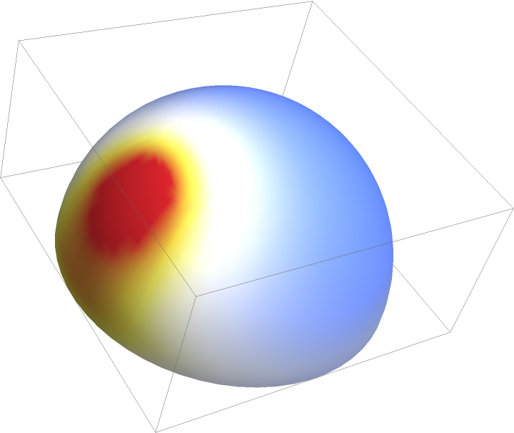
![SphericalPlot3D[1, {\[Theta], 0, Pi/2}, {\[Phi], 0, 2 Pi}, Mesh -> None, Axes -> False,
PlotPoints -> 60, ColorFunctionScaling -> False, ColorFunction -> Function[{x, y, z, \[Theta], \[Phi], r}, ColorData["TemperatureMap"][data[\[Phi], \[Theta]]/5]]]](https://www.wolframcloud.com/obj/resourcesystem/images/b87/b87ec7f8-9390-49e5-a179-c792cbc44b12/04a6cf61390921c2.png)

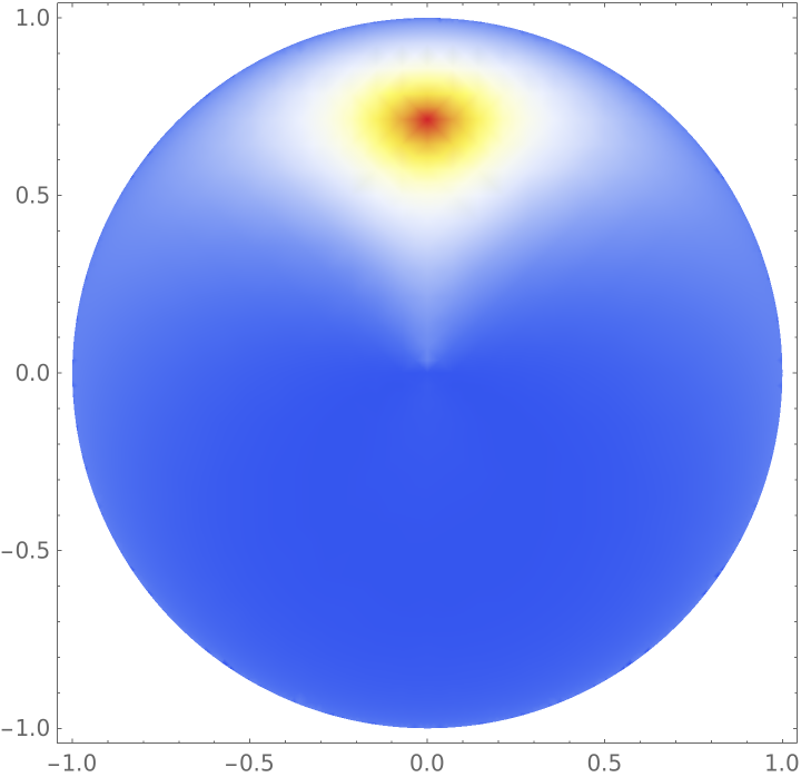
![data = ResourceFunction["StandardSkyLuminanceData"][8, "RelativeLuminance", Association["Azimuth" -> All, "ZenithAngle" -> All], Association["SolarAzimuth" -> 0, "SolarZenithAngle" -> Pi/4]]](https://www.wolframcloud.com/obj/resourcesystem/images/b87/b87ec7f8-9390-49e5-a179-c792cbc44b12/53877267d8bc8acd.png)
![DensityPlot[
data[ArcCos[y/Sqrt[x^2 + y^2]], ArcCos[Sqrt[x^2 + y^2]]], {x, -1, 1}, {y, -1, 1}, RegionFunction -> Function[{x, y}, x^2 + y^2 < 1], ColorFunction -> "TemperatureMap", PlotRange -> All]](https://www.wolframcloud.com/obj/resourcesystem/images/b87/b87ec7f8-9390-49e5-a179-c792cbc44b12/10b419c8d305f95e.png)
![ResourceFunction["StandardSkyLuminanceData"][2, "RelativeLuminance", Association["Azimuth" -> Pi/4, "Altitude" -> Quantity[30, "AngularDegrees"]], Association["Date" -> Now, "Position" -> Entity["City", {"NewYork", "NewYork", "UnitedStates"}]]]](https://www.wolframcloud.com/obj/resourcesystem/images/b87/b87ec7f8-9390-49e5-a179-c792cbc44b12/14251ef9bebd5a4d.png)
![ResourceFunction["StandardSkyLuminanceData"][4, "RelativeLuminance", Association["Azimuth" -> Pi/4, "Altitude" -> Quantity[30, "AngularDegrees"]], Association["Date" -> DateObject[{2012, 1, 2, 1}], "Position" -> GeoPosition[{40, -100}]]]](https://www.wolframcloud.com/obj/resourcesystem/images/b87/b87ec7f8-9390-49e5-a179-c792cbc44b12/7e3302547a034f93.png)
![ResourceFunction["StandardSkyLuminanceData"][4, "RelativeLuminance", Association["Azimuth" -> Pi/4, "Altitude" -> Quantity[-30, "AngularDegrees"]], Association["SolarAzimuth" -> Pi/4, "SolarAltitude" -> Quantity[30, "AngularDegrees"]]]](https://www.wolframcloud.com/obj/resourcesystem/images/b87/b87ec7f8-9390-49e5-a179-c792cbc44b12/60c3b6e4d2cb4112.png)